This is a 3-pack of different actual sea disasters and rescues. Each part of the adventure has an included flight plan file
for P3D/FSX to help you find the rescue site. Good Luck!
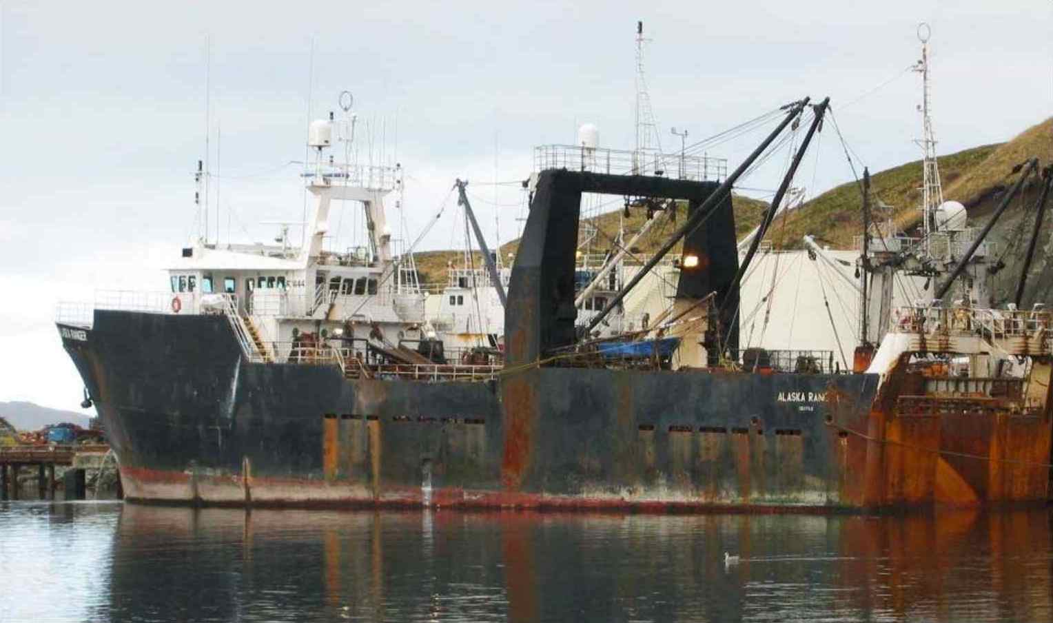
On March 23, 2008, FV Alaska Ranger sank in the Bering Sea, 120 nautical miles west of Dutch Harbor, Alaska. The Alaska Ranger had
left Dutch Harbor the previous day to fish on Petrel Bank, a fishing ground 500 nautical miles to the west. About 0230 on the morning
of March 23, the crew discovered flooding in the vessel's rudder room, and at 0246, the vessel broadcast a Mayday call. The U.S. Coast
Guard immediately launched search and rescue operations. The crew evacuated the vessel before it sank sometime after 0430. The Coast Guard
and the crew of another fishing vessel, the Alaska Warrior, rescued 42 of the 47 persons who had been on the Alaska Ranger. Five crewmembers
died in the accident. The wreckage of the Alaska Ranger lies in 6,000 feet of water at the bottom of the Bering Sea and was not examined.
-
[Flight# AP141 (PADU-PADU)] FV Alaska Ranger Rescue Mission
(PADU-FV Alaska Ranger-PADU)
-
Aircraft: Amphibian
-
Weather: Your choice - but the actual weather was Visibility: 10NM, Ceiling: 2500FT, Wind: NW 25KTS
-
Time: Night (2:46am)
-
Scenario:
You are stationed at Dutch Harbor, Alaska. At 2:46am a distress call is received from the Alaska Ranger and you are sent to respond
to the rescue call. The Alaska Ranger is sinking fast at the stern and the crew is abandoning ship. They are a day's journey out of
Dutch Harbor and report their current location at 53.88N/169.98W. A flight direct from Dutch Harbor 122nm on a 253 heading will take
you to the scene.
Fly from PADU to the Alaska Ranger, help rescue the survivors, and return to PADU to complete part-1 of this adventure pack.
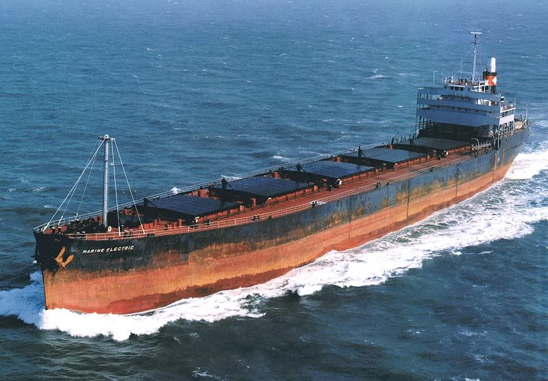
SS Marine Electric, a 605-foot bulk carrier, sank on 12 February 1983, about 30 miles off the coast of Virginia, in 130 feet of water.
Thirty-one of the 34 crewmembers were killed; the three survivors endured 90 minutes drifting in the frigid waters of the Atlantic.
The wreck resulted in some of the most important maritime reforms in the second half of the 20th century. The tragedy tightened inspection
standards, resulted in mandatory survival suits for winter North Atlantic runs, and helped create the now famous Coast Guard rescue swimmer program.
Recommended reading:
Until the Sea Shall Free Them
Here's a short Youtube Video about the Marine Electric Disaster
-
[Flight# AP142 (KORF-KDOV)]
(KORF-Marine Electric-KDOV)
-
Aircraft: Amphibious
-
Weather: Stormy
-
Time: Night (2:51am)
-
Scenario:
You are stationed at Norfolk International Airport (KORF) when a distress call is received from the Marine Electric. The distress call places the
ship's location at 37.88N/74.78W. Fly on a 53-degree heading from KORF 90NM to the Marine Electric and help with the rescue. Fly on to Dover AFB to
drop your surviors off and complete part-2 of this adventure.
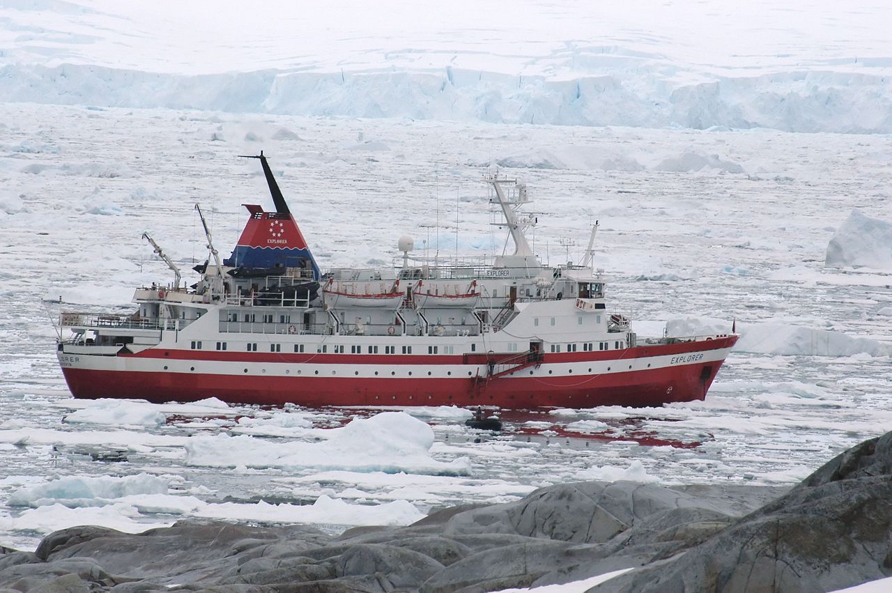
Explorer departed from Ushuaia, Argentina on 11 November 2007 on a 19-day cruise intended to trace the route of 20th century explorer Ernest
Shackleton through the Drake Passage (an area typically stormy with rough seas). After visiting the Falkland Islands and South Georgia she hit
an iceberg in the Bransfield Strait close to King George Island in the Southern Ocean, near the South Shetland Islands, on 23 November 2007.
The object struck by Explorer made a gash in the hull which allowed water to enter. The Argentine navy later said in a statement it observed "significant"
damage. The official report of the sinking noted: "The damage sustained had to have extended along the length of the vessel from Cabins 308 to 314 for at
least a distance of 3.6 meters, and, in all likelihood, had punctured and sliced holes along the shell plating."
Passengers on Explorer reported a loud "bang" at the time of impact, although others reported that there had been no noticeable impact, or at least
nothing more than the normal crunching of ice experienced when sailing through icy waters. One passenger reported sea water in their cabin at about
03:00 UTC. Some reports also indicate that the ship drifted into an iceberg on Explorer's starboard side while the crew was assessing damage caused by the
original impact, also to the starboard side of the ship.
A mayday call was put out by the ship at 04:24 UTC, and rescue operations were quickly coordinated by the Prefectura Naval (Coast Guard Corps) of Argentina
and the Chilean Navy Center for Search and Rescue. Chile dispatched the icebreaker Almirante Viel, and nearby commercial ships including the MN Ushuaia, the
National Geographic Endeavor, and the Norwegian Coastal Express ship MS Nordnorge which was operating as a passenger cruise ship at the time. By 07:30 UTC,
all 91 passengers, 9 guides and 54 crew, from over 14 countries, were evacuated and had taken to the Explorer's lifeboats. The evacuees drifted for 5 hours
until they were picked up by the Norwegian ship MS Nordnorge which arrived on scene at approximately 10:00 UTC.
All of those rescued by Nordnorge were taken to the Chilean Frei Montalva Station on King George Island where they were subsequently airlifted by C-130
Hercules transport aircraft of the Chilean Air Force to Punta Arenas, Chile in two separate flights, one on Saturday 24 November and the other on Sunday
25 November. Those passengers not taken to Punta Arenas (an estimated 70) were taken to Uruguay's Artigas Base. Explorer was completely submerged at 19:00
UTC, approximately 20 hours after the initial impact and damage to her hull.
Here's a short Youtube Video about the Explorer sinking:
-
[Flight# AP143 (SCRM-SCRM)] (SCRM-MV Explorer-SCRM)
-
Aircraft: Amphibious
-
Weather: Clear
-
Time: Dawn
-
Scenario:
You are stationed at Teniente Rodolfo Marsh Martin Airport on King George Island (SCRM) when a distress message is received from
MV Explorer. Take off from SCRM fly on a 84-degree heading 51NM to the rescue site. The coordinates given by the distressed vessel are
62.24S/57.16W. However, you can easily find this scene by flying along the SE side of King George Island until you come upon a series of
iceburgs near the northern tip of the island. Follow the iceburgs out to sea to the scene of the rescue. You might also watch for distress rockets here.
Rescue the passengers and crew and return them to SCRM to await the C-130 transport home. This completes part-3 of this adventure.